Metria® Maps mapping service is a fast and stable mapping service that easily integrates into your business systems.
Are up-to-date maps important in your business?
Metria Maps is a fast and stable mapping service that easily integrates into your business systems. Users get access to reliable, updated and quality-assured maps, customized to what you need.
The maps are based on fresh geodata from Lantmäteriet and other suppliers, all in uniform and attractive cartography delivered from Metria's own operating environment.
Tailored features and customized content in Metria Maps ensure that you get the data that is most useful to your business. The maps can be combined with different layers of information or used to connect with information from other sources, such as Metria FastighetSök
Want to know more? Contact us for more information.
Integrated maps - Easiest way to integrate maps into applications
In Metria Maps there are over 100 different map layers that are important to consider when planning and analyzing. These layers help to ensure that the right consideration is given to both nature and different stakeholders.
Background maps
Discover the power of Metria's "Background" maps - your ultimate solution for detailed and reliable geographic information. Our maps offer a clear overview of roads, buildings, water bodies and terrain, making them perfect for all types of analysis and visualization. With high resolution and accurate updates, Metria's maps ensure that you always have the most up-to-date and accurate information at your fingertips.
Background maps are used as a visual base to add other information, such as property boundaries, roads, buildings and natural resources. They serve as a basic reference point and can be customized for different uses and needs.Real estate map
Metria offers different types of property maps, general and detailed. A detailed map showing the boundaries, size and layout of one or more properties. Fastighetskartan plus offers detailed maps of properties in Sweden.
Orthophoto
Orthophotos are geometrically corrected aerial images that are put together to create a scale representation of the ground. They are available all over Sweden. It is often used as a valuable basis together with other geodata in many different industries.
Satellite imagery
We offer high-resolution satellite images that can be used, for example, for forestry, environmental monitoring, and urban planning. Saccess satellite images have color spectrum, where you can distinguish different vegetation and the status of plant populations.
Discover the right map solution for your business - over 100 customized map layers
At Metria, we offer over 100 customized map layers, carefully designed to meet our customers' unique needs. Whether you work in urban planning, environmental monitoring or any other industry, we have a solution to suit your business.
We support the following formats: OGC, WMTS and ArcGIS. Explore our packages and find the perfect mapping service to take your business to the next level.
With Metria Maps you get


Easy to use
Fast, up-to-date, quality-assured and user-friendly maps directly accessible in your systems.

Tailored to your needs
The map service can be easily customized to work optimally with your needs and procedures. Style, function or content - anything is possible.

Easy to integrate
A machine-to-machine service in both OGC and ArcGIS REST technologies that easily integrates with existing products and solutions.
Here you can see a selection of our map layers.
The map service contains rights (e.g. rights of way and road rights) and common facilities (e.g. road associations, water and sewage facilities, bathing places) that are linked to a specific property. The map provides a good overview of the existence and extent of rights of way, which are interesting in connection with different types of projects.
The map layer provides a good overview of the plans and land-use regulations that apply to a particular area or property, such as detailed plans, subdivision plans, building plans, etc.
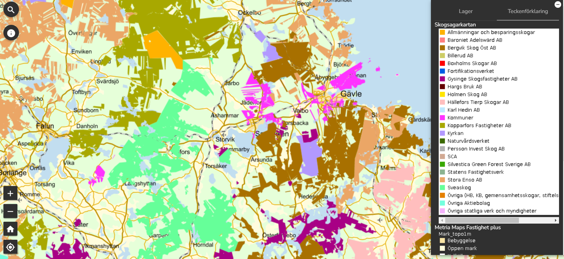
The forest owner map shows Sweden's major forest owners at national level and gives you a quick overview of their holdings. The map is suitable for general planning and is useful for those who:
- want an overview of the holdings of the major forest owners (often the Swedish state or forest companies)
- want to know which large forest owners are in your area of interest
- are a timber buyer for the private market - you can see at an early stage which areas the large forest owners own
The forest owner map is the result of careful analysis of property boundaries and ownership information from the land registry, based on properties owned by legal entities with a holding of at least 1000 ha of forest. The map is updated once a year and can be delivered both as a map service and a file delivery.
For accurate search of affected landowners on individual properties for, for example, mailing or other contact, we recommendMetria FastighetSök or Metria Fastighetsuttag for the highest timeliness and reliability.

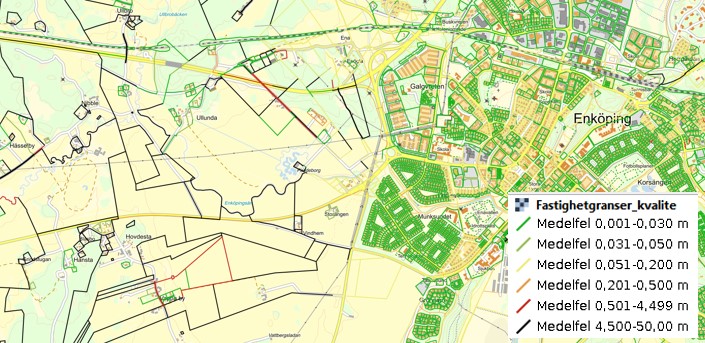
The position of property boundaries on the map may look very definite and obvious, but in fact they have a positional uncertainty that can be both large and small, depending on the accuracy with which they are measured. When working in the field, questions can arise that sometimes require pure detective investigations to bring clarity.
Metria makes it easier for you by offering a separate map layer with the positional uncertainty of the property boundaries so that you know what margins your project needs. If needed, you can also get in-depth property information.
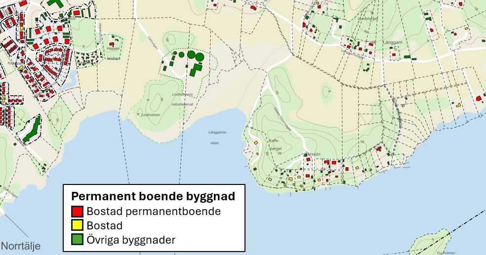
Land use changes usually require the permission of both the authorities and those affected. An aerial photograph or a standard background map does not usually show everything in a given study or project area. If the map contains sufficient information, it is possible to prioritize the placement of infrastructure. This may involve, for example, connecting or avoiding impacts on properties where there are dwellings, permanent housing, holiday homes or other buildings. It can also be important to understand whether a project intersects with other activities, especially before a consultation process. Metria is happy to help you package the information you need to make safer decisions.
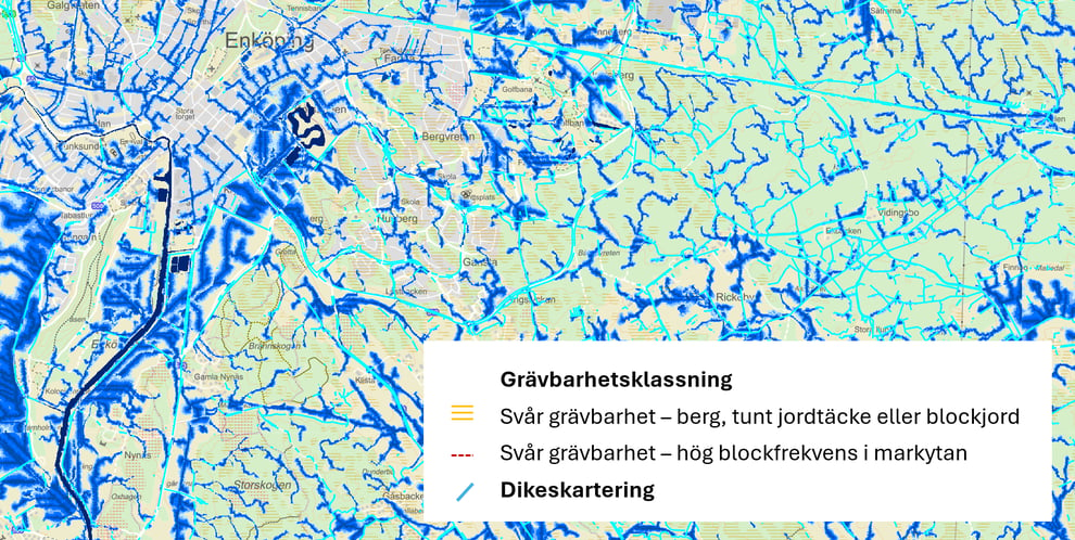
When developing infrastructure such as electricity networks, fiber, water, sewage and district heating, excavation is of interest. Discovering bedrock or encountering areas of excessive soil moisture can delay, cost and, in the worst case, stop a project. Therefore, it is important to identify in advance routes with suitable soil depth, free from contamination and without other obstacles. Information showing whether it is an area of high ecological status and species richness or whether it is full of invasive species is also important .
At Metria, we help you as a project manager to ensure that you have the right data. If you are a GIS specialist and want to perform more advanced analyses, we can also help you avoid the sometimes laborious work of identifying and maintaining all the data.
Sveaskog gets high quality and delivery reliability with Metria Maps
With its three million hectares, state-owned Sveaskog is Sweden's largest forest owner. In order to conduct extensive, sustainable and efficient forestry, large amounts of geodata of various types are required. Sveaskog meets the entire organization's need for updated information in an efficient way with the map service Metria Maps.
Our own data combined with external geodata is a prerequisite for making the decisions required for sustainable and efficient forestry. We manage large areas and it is important to be able to make an accurate assessment in the field. Geodata provides an overview and understanding of what is in and around an area even before we visit the site.
There are many suppliers who can deliver expertise and solutions on the client side, but when it comes to storing and delivering geodata, the range is more limited. It feels safe that Metria sees this as its main task.
Mattias Tengbrand is a system administrator in the IT department at Sveaskog in Östersund. He is responsible for ensuring that the organization has access to the geographical information (geodata) they need.
E-mail: fredrik.olsson.alvebro@metria.se
Telephone: 010 121 87 66
Articles in the knowledge bank
Skred och erosion – risker du inte vill missa
Vi har kompletterat med nya hänsynskartskikt
All geografisk information du behöver – samlad på ett ställe
More of our services
Metria Soil Model is a basic package of data for those who need a soil model...
Read moreMetria Property Report gives you information about a property in the form of: Address, Location, Area, Title...
Read moreMetria SeSverige is an e-commerce portal where you quickly and easily get delivery of maps and images.
Read moreGet in touch with us!
Want to know more or have questions? Feel free to contact us.