Fast, updated map service in your system
Metria® Maps

Metria Maps facilitates the identification of climate-related risks
What was previously considered safe may now have changed conditions.
There is information available on risk areas for floods, landslides, mudslides, or erosion.
For forestry, it is useful to know where harmful insects such as bark beetles are widespread or where the risk of fire is high.

The location shown is Henån, 120 kilometers east of Fiskebäckskil.
Map with rights
The map service contains rights (e.g. rights of way and rights of way) and community facilities (e.g. road communities, VA facilities, bathing areas) that are linked to a certain property. The map gives a good overview of occurrences and distribution of management rights, which are interesting in connection with different types of projects.

Land regulatory provisions
The map layer provides a good overview of which plans and land regulatory provisions apply to a certain area or property, e.g. detailed plans, subdivision plans, building plans, and more.

The forest owner map provides an overview of Sweden's largest forest owners
The forest owner map reports Sweden's large forest owners on a national level and gives you a quick overview of their holdings. The map is suitable for overview planning and is useful for you as: want an overview of the holdings of the large forest owners (often the Swedish state or forest companies) want to know which large forest owners are in your area of interest are timber buyers against the private market - already at an early stage you see which areas the large forest owners own The forest owner map is the result of careful analysis of property boundaries and owner information from the land register, based on properties owned by legal entities with a holding of at least 1000 ha of forest. The map is updated once a year and can be delivered both as a map service and file delivery. For a thorough search of affected landowners on individual properties for e.g. mailing or other contact, we recommend Metria FastighetsSök or Metria Fastighetsuttag for maximum timeliness and reliability.


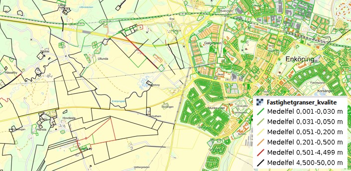
How do you handle ambiguities in the map?
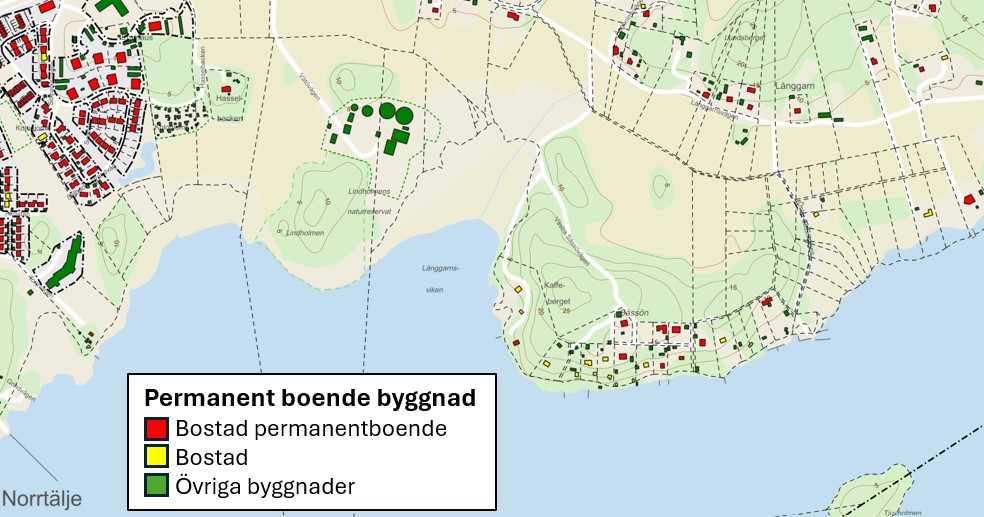
Permanent residence, businesses and other stakeholders
In the event of a change in land use, permission is usually required from both the authorities and those concerned. An aerial photograph or a standard background map usually does not show everything in a current investigation or project area. If the map contains sufficient information, there is the possibility of prioritizing the placement of infrastructure. For example, it may be about connecting or avoiding impact on properties where there are homes with, permanent residences, holiday homes or other buildings. Whether a project affects other activities can also be important to understand, especially before a consultation process. Metria will be happy to help you package the information you need to make safer decisions.
Accessibility when new infrastructure is laid in the ground
When expanding infrastructure such as electricity grids, fiber, water, sewage and district heating, diggability is of interest. Discovering rocks during the day or encountering areas with excessive soil moisture can delay, increase costs and, in the worst case, stop a project. Therefore, it is important to identify in advance lanes with suitable soil depth, free of pollution and without other obstacles. Information showing whether it is an area of high ecological status and species richness or if it is full of invasive species also comes into play. At Metria, we help you as a projector to ensure that you have the right documentation. As a GIS specialist who wants to do more advanced analyses, you can also get help in avoiding the sometimes arduous work of identifying and maintaining all the data.


Sveaskog gets high quality and delivery security with Metria Maps
With its three million hectares, Statliga Sveaskog is Sweden's largest forest owner. In order to carry out extensive, sustainable and efficient forestry, large amounts of geodata of various types are required. Sveaskog meets the entire organization's need for up-to-date information in an efficient way with the Metria Maps map service.
Our own data in combination with external geodata is a prerequisite for making the decisions required for sustainable and efficient forestry. We handle large areas and it is important to be able to make a proper assessment in the field. Geodata gives an overview and understanding of what is in and around an area even before we visit the place. There are many suppliers who can deliver expertise and solutions on the client side, but when it comes to the storage and delivery of geodata, the range is more limited. It feels safe that Metria sees it as its main task.

Mattias Tengbrand is a system administrator at staff IT at Sveaskog in
Östersund. He is responsible for ensuring that the organization has access
to the geographic information (geodata) that they need.