
Through the "Agenda for the Landscape" project, nine collaborating authorities* want to ensure that there is always up-to-date, high-quality and open data on the landscape and land use in Sweden. The project has developed innovative methods for efficient updating of national land cover data with the support of automation, time series analysis and machine learning.
Many need up-to-date land cover data
An up-to-date and comprehensive mapping of Sweden's land cover is an important basis for the conservation of biodiversity, sustainable land use, ecosystem services, urban development and planning, and climate and risk management. It is also used to monitor the goals of the 2030 Agenda for Sustainable Cities, Ecosystems and Biodiversity.
In 2017-2019, Metria, on behalf of the Swedish Environmental Protection Agency in collaboration with several Swedish authorities, conducted a nationwide mapping of land cover. The result is National Land Cover Data (NLCD) in raster format with 10 meter resolution consisting of 25 thematic classes in three hierarchical levels.
- Today, high-resolution land cover data is an important basis for analysis for many authorities, municipalities and organizations. They provide basic information on the composition of the landscape and are used, among other things, to monitor changes over time, but this requires continuous updating," says Birgitta Olsson, project manager, Swedish Environmental Protection Agency.
'Agenda for the landscape' ensures up-to-date NMD
The "Agenda for the Landscape" project was initiated in 2018 with the aim of developing innovative methods for efficiently updating the information, increasing the information content and improving the reliability of the mapping. It has been co-financed by Vinnova in the "Challenge-driven innovation" program. The collaborative phase of the project was completed in January 2022.
- "It has been a very exciting and instructive project for us at Metria as we have had to work with methods with a very high degree of innovation. We have been responsible for, among other things, method development and production of the test areas, says Maria Nilsson, Group Manager, Metria.

Collaboration important for success
The project has been based on established collaborations between several authorities and the requirements and needs have been collected in close dialogue with around 30 different organizations through various theme groups. The theme groups have developed recommendations on the information content for forests, open wetlands, agricultural and other open land, mountains, water and built-up areas/developed land. The theme groups have also evaluated the test data produced.
- The collaboration between authorities, research institutions and industry, which has been central to the entire project, has greatly contributed to its success. Although virtually all the work was done remotely, good forms of collaboration have created both commitment and new contacts. The project has led to many valuable new collaborations, networks and contacts," says Birgitta Olsson.
Automated methods, technology and processes
|
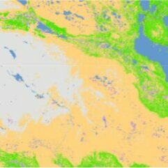
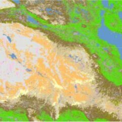
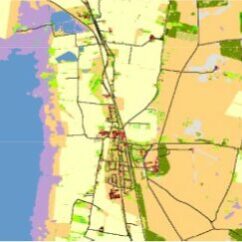
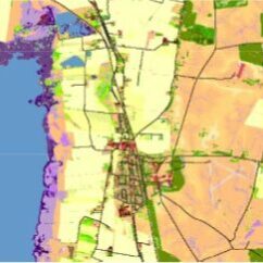
An important part of the project was to develop methods, technology and processes for updating with a focus on automation, time series analysis and machine learning. To verify these, three test areas were produced with extended information content and higher accuracy. The evaluation of the results shows that the methods significantly improve the existing classes and map the new ones with high accuracy. In the figure below you can see that the information content between the current version NMD v.1.1 (left) and the test product NMD v.2 (right) has been extended based on the user needs that emerged during the project. The two images on the left show an area in the mountains and the right images show an area in southern Sweden. |
 |
 |
 |
 |
 |
Target image fulfilled
In January 2022, after two years, the collaboration phase of the project ended. Results and expected impacts have been achieved. Participating organizations consider that the collaboration has worked very well and there is a consensus to now work on an implementation phase of the project. The technical work has been successful and the production of three test areas has shown that the requested information can be produced more automatically and with a high level of accuracy.
- We have learned a lot in the project and are very pleased that the testing of the methods turned out so well. It shows that we can produce the information efficiently with both higher accuracy and more automation, which was one of the goals of the project, says Maria Nilsson, Metria.
- "We and the other eight authorities that collaborated are all satisfied with the outcome of the project. We have obtained a very good basis for decisions on future management and financing. We are now working to ensure that NMD is given the status of national basic data," says Birgitta Olsson NV.
* The authorities that collaborated are the Swedish Environmental Protection Agency, the Swedish Forest Agency, the Swedish Agency for Marine and Water Management, the Swedish Civil Contingencies Agency (MSB), Lantmäteriet, the Swedish Board of Agriculture and Statistics Sweden (SCB), the Swedish Transport Administration and the Swedish University of Agricultural Sciences.
INNOVATION AWARD
National Land Cover Data awarded innovation prize
National Land Cover Data was awarded the Cartographic Society's Innovation Prize in 2021 with the motivation:
"For the development of the National Land Cover Data and its complementary products. It has quickly become invaluable basic data for a large number of users in the work on biodiversity, sustainable land use, ecosystem services, urban development and planning, and climate and vulnerability. Through collaboration between authorities, resources have been used efficiently to produce a nationwide mapping that creates a better understanding of Sweden's land use within the Swedish environmental work and stimulates further development of analyzes and follow-up products."