
Under its framework agreement with MSB, Metria has carried out national heat mapping using satellite data and developed a service for mapping ground temperature in Sweden. The map is displayed in a service where the information can also be downloaded divided by municipality, county and the whole of Sweden. The information consists of five raster layers where the pixel value describes the highest ground temperature during different three-year periods. A 6th raster layer shows the maximum temperature for the entire analyzed time period. There is also a vector layer showing soil surface temperatures exceeding 35 degrees. The map can also be viewed through a display service (WMS).
The heat map service is available on MSB's website MSB Värmekarta (metria.se)
A socially beneficial project that contributes to municipalities' climate adaptation work
The mapping can be used to identify specific hot spots that can have a negative effect on society. During heatwaves, hotspots can reach temperatures that can be harmful to the population. The map service is intended to be used, among other things, for community planning in municipalities' climate adaptation work, which will help them see how they can relate to warmer and cooler areas.
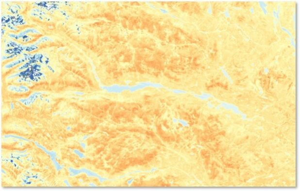
Heatwaves do not only occur in big cities. It was an unexpected surprise that the mountains, especially on the southern slopes, would get so hot during the summer. The image shows the mountains directly west of Kiruna. Dark blue and white are snow- and ice-covered peaks.
- This project is particularly gratifying for me because it involves something I love to do - working at the cutting edge of remote sensing with high-resolution images from the latest NASA and ESA satellites. And that it can be combined with helping municipalities address the complex issues that have arisen due to climate change," says Michael Ledwith, Senior GIS and Remote Sensing Consultant at Metria.

Here's how the measurement and mapping was done
The heat mapping was carried out using satellite measurements via an American satellite, Landsat, which passes Sweden every 14 days. It has measured the ground temperature via a thermal sensor and Metria has downloaded the data and calculated the maximum temperature per pixel and compiled a map of Sweden.
The heat map records, among other things, the areas affected by forest fires in Sweden in summer 2018. Around 50 forest fires covering 25 000 hectares of forest destroyed the forest and left the land without vegetation. Vegetation keeps temperatures down, and its disappearance means that the areas still show up well on heat maps.
Another place that stands out is southern Öland, the Great Gravity, where the exposed Öland stone absorbs heat. There are also heat islands in the Swedish mountain regions, where the mountain tops get warm where there are bare mountains.
- "It is interesting to map the whole country as you see warm and cool areas even outside urban areas," says Susanne Ingvander, Senior GIS and Remote Sensing Consultant at Metria.

The effects of heatwaves on society
Heatwaves are expected to become more frequent, more intense, longer lasting and more frequent in the future and are the climate effect expected to have the greatest impact on health in Europe. The impact on essential activities outside the health sector can also be significant during a heatwave. MSB has conducted several studies on the effects of heat on essential activities in Sweden. Source: Heat wave (msb.se)
In urban areas, a local climate is created that means that the population there can be more exposed to heat than in more sparsely populated areas. This is particularly true of densely built-up areas with a high proportion of hard surfaces and little vegetation. In such areas, both air temperature and radiant temperature can be high and there is a higher risk of so-called heat islands forming.
People in larger cities are particularly vulnerable during heatwaves as built-up areas create higher temperatures than their surroundings through heat storage, also known as the urban heat island effect.
Unhealthy temperatures
High temperatures over a long period of time can have negative effects on our health. Young children, the elderly and sick people are particularly vulnerable, making temperature reduction measures in urban planning even more important in a changing climate. High temperatures can also damage important technical equipment.
The importance of breaking hot surfaces with cool green spaces
The factors that seem to have the greatest impact on heat islands are the density of buildings and the proportion of green space that is cool. Vegetation has a temperature-lowering effect through shading and the cooling effect of plant transpiration and evaporation. Urban areas generally have a low proportion of vegetation. Source: Mapping of buildings at risk of high temperatures (folkhalsomyndigheten.se)