
The Environmental Protection Agency was tasked by the appropriation directions with producing documentation that identified areas suitable for rewetting for climate benefits, with a focus on measures on agricultural land. The assignment is carried out in collaboration with several authorities, but primarily the Swedish Board of Agriculture. Metria produced a national GIS database showing potential wetland areas to be rewetted with associated potential impact areas in order to contribute to climate benefits, with the possibility of development for assessing benefits for biodiversity, water balancing, water quality and groundwater.
The evidence is needed to assess potential Section 9.4 commitments arising from the EU restoration legislation currently under negotiation.
- In order to locate peatlands on agricultural land suitable for rewetting, soil data from SGU and SLU's peat map have been overlapped with blocked agricultural land. In addition, the areas have been overlapped with the national ditch map produced by SLU and the Swedish Forest Agency, but refined by Metria, to find the drained areas," says Christoffer Keskitalo, GIS and remote sensing consultant at Metria.

- "It has been a very enjoyable project that has included a lot of method development and investigation of relevant factors for wetland rewetting. It has also involved several meetings with different authorities and it has been interesting to hear the focus of the different actors when it comes to wetlands and restoration. We look forward to further developing the work both for the Swedish EPA and for other clients and have many ideas for further analysis! says Cecile Bouju, Junior GIS and Remote Sensing Consultant.

Elevation data for wetland modeling
To find suitable areas to rewet, it is not enough to examine the soil type, but it is important to see how big the potential wetland would be and how far the impact area extends. The potential constructed wetlands are areas that will have a groundwater level at or above the ground surface. The area of influence is defined as all land that may have an elevated water table down to 1.2 m below the ground surface, which is considered insufficiently drained land for agriculture. Elevation data were used to model potential constructed wetlands and their associated area of influence when plugging ditches. The model first identifies plugging locations by searching for the point of highest flow accumulation adjacent to a ditch, and then fills the ditches in the elevation model to simulate ditch plugging. The model then delimits, based on the height of the theoretical plugging position, other adjacent heights that are higher or lower than the plugging position. Delineation is also made against the catchment area of the plugging location as the effect of plugging is mainly expected to occur upstream of the plug.
Constructed wetland models were attributed with map data
Once potential constructed wetlands and associated impact areas were modeled, they were attributed using other map data to assess their suitability for physical measures. Among other things, information on the area of each class in NMD (National Land Cover Data), the number of affected properties, ditch density and landowner type was added. This was done, for example, to be able to sort out potential wetlands and impact areas that could already constitute a wetland, or where the impact area extends beyond exploited areas and would then not be suitable for implementing measures.
Methodology for future analysis for biodiversity benefits
The method can be used in the future to perform more detailed analyses on a smaller scale with higher resolution, for example for municipalities or county administrative boards. Once potential wetland areas have been identified, the analysis can be developed to investigate synergies with other benefits such as water purification, groundwater recharge, and biodiversity.
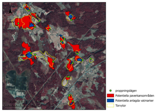
Figure 1: An area with well-defined boundaries of potential constructible wetland areas (in blue) and impact areas (in red). Associated peatlands are outlined in yellow and theoretical plugging locations in green To determine potential suitability and feasibility, associated attribute information can be used.
Wetlands are important for biodiversity
Wetlands are among the most species-rich environments in Sweden and are important for biodiversity. Wetlands contribute to a wide range of ecosystem services that we depend on. Because they can sequester carbon dioxide, they also play an important role in mitigating climate change.
Wetlands in Sweden have declined significantly in number. Over the last century, almost a quarter of the original wetland area has disappeared. When wetlands are reduced or damaged, their biodiversity, important benefits and functions are also lost.
On the positive side, many of Sweden's wetlands are in relatively good condition compared to the situation in other countries. In addition, since the 1980s, wetlands have gradually received stronger protection and there is great interest in preserving, restoring and creating new wetlands.
Source: Swedish Environmental Protection Agency - wetland facts